Western North Carolina is Water Country
Western North Carolina sits at the headwaters of some of the Southeast’s great river systems. Water that falls on these mountains begins journeys that carry it far beyond our region, into reservoirs, farms, cities, wildlife habitats and communities across several states. What happens here matters downstream. The health of our forests, streams and rivers affects the water people drink, the fish and wildlife that depend on it, the places we swim and paddle, the farms that rely on it and the communities that face both drought and flooding. Protecting water in the mountains means protecting much more than the water we can see from here.
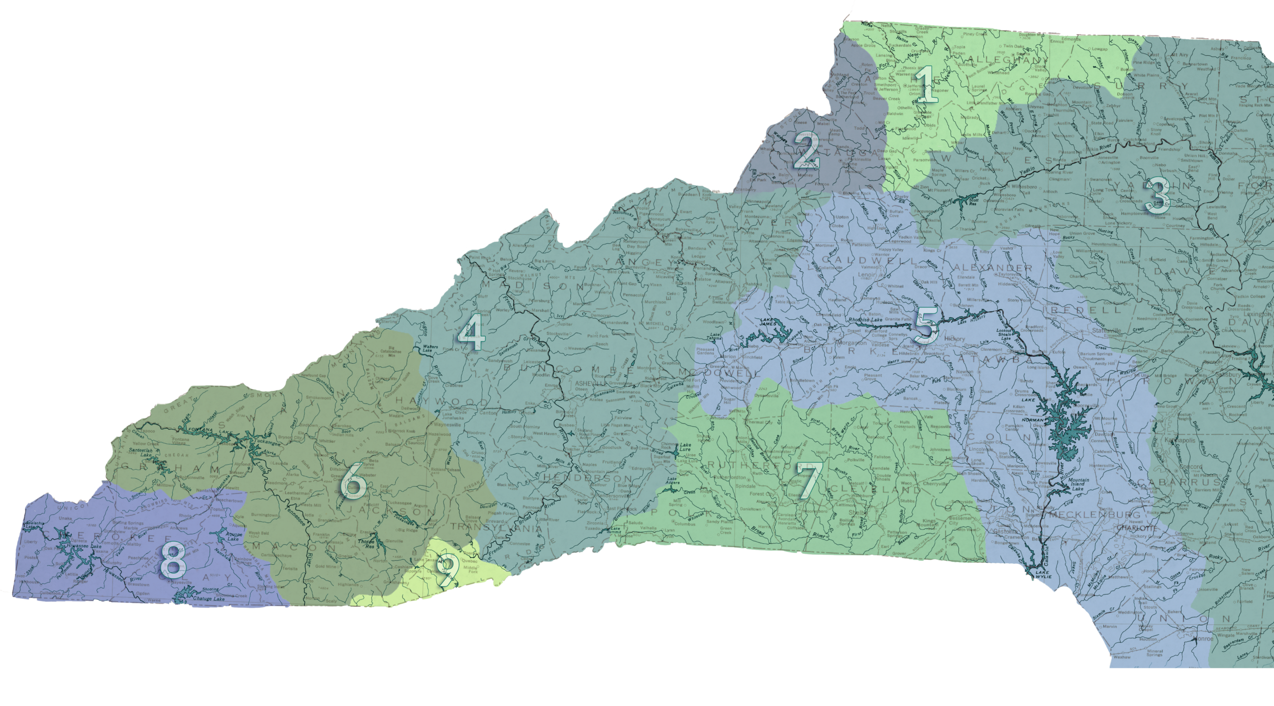
Western North Carolina holds the headwaters of nine major river basins, each carrying mountain water in a different direction. From north to south and west, they include the New River Basin (1), drained by the North and South Forks of the New River; the Watauga River Basin (2), including the Watauga and Elk rivers; the Yadkin–Pee Dee River Basin (3), beginning with the upper Yadkin and its tributaries; the French Broad River Basin (4), home to the French Broad, Pigeon and Swannanoa rivers; the Catawba River Basin (5), built around the Catawba and South Fork Catawba; the Little Tennessee River Basin (6), which includes the Little Tennessee, Tuckasegee, Nantahala, Cullasaja and Cheoah rivers; the Broad River Basin (7), including the Broad, Green, First Broad and Second Broad rivers; the Hiwassee River Basin (8), centered on the Hiwassee and its mountain tributaries; and the small Savannah River Basin (9), whose North Carolina headwaters include the Chattooga, Whitewater, Horsepasture and Toxaway rivers. Together, these watersheds send water from our mountains toward both the Atlantic Ocean and the Gulf of Mexico.
Is the water safe?
We are fortunate to have a great many River Keeper organizations working together to test the safety of the water in our region. They report each week during the warmer seasons about hundreds of different locations. If you have location enabled on your device, this map should show you if the water near you is safe.
The following links are tremendously useful for checking changing safety conditions regarding water.
This is an important tool provided by the United States Environmental Protection Agency. Just provide your zip code. The information provided will tell you how healthy your local waterways are in real time.
Who is Watching our Water?
Riverkeepers are independent advocates, not government regulators. They cannot issue fines or revoke permits. Instead, they spend time on the water monitoring conditions, collecting samples, investigating pollution reports, reviewing permits, organizing citizen scientists, educating communities and pushing agencies and elected officials to act when water is threatened.
Think of them as an independent set of eyes and ears on the river.
Yadkin Riverkeeper works throughout the Yadkin-Pee Dee watershed. The organization monitors and samples the river and its lakes for pollution, alerts officials and the public to threats, provides education and advocates for policies that protect water quality.
MountainTrue operates a large Clean Waters program across Western North Carolina and is home to several of the Riverkeepers serving our region.
The French Broad Riverkeeper monitors the French Broad watershed, coordinating water-quality monitoring, citizen science and projects aimed at improving the river and its tributaries.
The Broad Riverkeeper works throughout the Broad River watershed, including the Broad and First Broad rivers, monitoring water quality and advocating for the rivers and communities that depend on them.
The Green Riverkeeper focuses on the Green and Pacolet watersheds, which are part of the larger Broad River system. The program conducts water sampling, streambank restoration, pollution and debris response, community outreach and advocacy.
The Watauga Riverkeeper works in the Watauga watershed and surrounding High Country, monitoring water quality, responding to pollution and working on projects that protect streams, aquatic habitat and the communities that depend upon them.
The Upper New Riverkeeper is dedicated specifically to the North Carolina headwaters of the New River. The program works with local communities on water-quality monitoring, pollution response, education and partnerships to protect one of the oldest river systems in the world.
Not every organization protecting our water carries the Riverkeeper name.
Mainspring Conservation Trust is especially important in far-western North Carolina. Its work combines land conservation with stream restoration, aquatic biomonitoring, water-quality monitoring, citizen science and volunteer opportunities. Protecting land along rivers and streams also protects the water itself by preserving forested buffers, wetlands and headwater areas.
The Watershed Association of the Tuckasegee River (WATR) is a grassroots organization focused on the Tuckasegee watershed. Volunteers conduct water-quality monitoring, work on streambank and riparian restoration and help educate the public about the watershed.
New River Conservancy works throughout the New River watershed on water quality, stream and riverbank restoration, land conservation, research, cleanups and public advocacy. Its work extends beyond North Carolina as the New continues through Virginia and West Virginia.
RiverLink has worked for decades along the French Broad and its tributaries, with an emphasis on river and stream restoration, environmental education and connecting people with their watershed.
Foothills Conservancy of North Carolina is a land trust rather than a Riverkeeper organization, but much of its conservation work protects springs, creeks, wetlands, stream corridors and headwater lands within the Catawba, Broad and Yadkin watersheds. Protecting those places helps protect the water flowing downstream.
See a sewage spill, fish kill, strange-colored water, oil, chemical discharge or other water emergency?
The NC Department of Environmental Quality Division of Water Resources coordinates response to incidents including sewage spills, oil discharges, fish kills and algal blooms that threaten surface waters.
During normal business hours: Contact the Division of Water Resources regional office that serves the county where the problem is occurring.
After hours, on weekends or holidays: Call the state environmental emergency number:
1-800-858-0368
If there is an immediate danger to people or property, call 911 first.
A good report can make it much easier for investigators — or your local Riverkeeper — to find the problem and determine what happened.
- Take photographs and video. Get both close views and wider shots that show where the problem is located.
- Record the exact location. Drop a pin on your phone, save GPS coordinates or note the nearest road, bridge, access point or landmark.
- Write down the date and time.
- Describe what you see. Note unusual color, cloudiness, foam, scum, oily sheen, dead or distressed fish, trash or other visible material.
- Describe what you smell. Sewage, petroleum, chemicals, rotten-egg odors and other unusual smells can be important clues.
- Look for a possible source from a safe, legal location. A pipe, ditch, culvert, drain, construction site or flow entering from upstream may help investigators locate the source.
- Note recent weather. Heavy rain — or the absence of it — can sometimes be useful information.
- Notice how far the problem extends. If you can safely see whether it continues upstream or downstream, include that in your report.
Do not wade into, touch, smell closely or collect samples from water you think may be contaminated. Don't trespass to follow a pipe or discharge, and don't confront someone you believe may be responsible.
Your photographs, location and observations are enough to make a useful report.
After making any necessary official report, consider sending the same information to your local Riverkeeper.
Riverkeepers are independent watershed advocates. They patrol waterways, investigate pollution complaints, conduct water-quality monitoring and can often follow up on a problem over time. Photos, video, a location pin and the information you gave DEQ can be extremely useful to them.
Find Your Local Waterkeeper → Waterkeepers Carolina
Reporting to a Riverkeeper does not replace notifying DEQ when there is an active spill or environmental emergency. Think of the two roles differently: DEQ is the regulatory agency responsible for the official response; your Riverkeeper is an independent advocate watching the watershed and its communities.
NC DEQ also has an online reporting form specifically for fish kills and suspected algal blooms. If you encounter one, photograph it from a safe distance, record the location and submit the report as soon as possible.
Oil spills that reach surface water have an additional federal reporting requirement. NC DEQ directs those incidents to be reported to both North Carolina and the National Response Center at 1-800-424-8802.
When in doubt, report what you see. You aren't expected to investigate the pollution yourself — that's what the people receiving the report are there to do.
Find your Riverkeeper
Ways to Help Protect Our Water
Protecting a river does not have to mean writing a check. Some of the most useful work happens a few hours at a time, along a neighborhood creek, at a cleanup, or simply because somebody noticed that something had changed.
Give a Few Hours
Local Riverkeepers and conservation organizations regularly need volunteers for river cleanups, invasive-species removal, stream restoration, water sampling and other hands-on projects.
MountainTrue maintains a current calendar of volunteer opportunities across Western North Carolina, including river cleanups and Riverkeeper events.
Volunteer with MountainTrue
Mainspring Conservation Trust also uses volunteers for water, land and conservation projects in the far-western counties.
Volunteer with Mainspring Conservation Trust
Not sure which organization works where you live? Start by finding your local Waterkeeper.
Find Your Local Waterkeeper — Waterkeepers Carolina
A few hours pulling trash from a creek bank or helping restore a stream may seem small. Multiplied across a watershed, it is not.
Keep an Eye on a Stream
You don't need special equipment to begin paying attention to the water near your home.
NC Stream Watch, a program of the NC Department of Environmental Quality, invites residents to observe local streams and rivers, submit photographs and observations, and explore what other people are seeing across the state. DEQ describes it as a community-science project, and you do not have to be a trained hydrologist to participate.
Pick a creek you pass regularly and get to know it. Notice its normal color and flow. Pay attention after storms. Look for new erosion, trash, muddy runoff, unusual algae, dead fish, strange odors or a discharge that wasn't there before.
People who know a stream well are often the first people to realize something has changed.
Become a Citizen Scientist
You don't have to be a professional biologist to collect information that helps protect a river.
MountainTrue's Riverkeepers and volunteers collect water samples across Western North Carolina, including regular summer bacteria monitoring for Swim Guide. That information helps tell people where it is safe to swim, but MountainTrue also uses the data to identify pollution sources and track the health of rivers over time.
MountainTrue Clean Waters & Water-Quality Monitoring
In far-western North Carolina, Mainspring Conservation Trust works on stream restoration and aquatic biomonitoring as part of its broader land-and-water conservation work.
Mainspring Aquatic Biomonitoring and Water Work
Your local Riverkeeper may have additional sampling, cleanup or monitoring opportunities in your particular watershed.
Community monitoring matters because rivers are enormous systems. Agencies and nonprofits cannot be everywhere every day. A volunteer who returns to the same stream month after month can sometimes document a change that a single inspection would never reveal.
Protect the Creek Behind Your House
You don't have to live beside the Catawba, French Broad, New or Watauga to affect a river.
The ditch along your road, the little branch behind your neighborhood and the creek crossing a pasture are all connected to larger waterways. What happens beside those small streams eventually moves downstream.
- Maintain a vegetated stream buffer.
Leave trees, shrubs, grasses and other vegetation beside streams whenever possible. Their roots stabilize streambanks, while the vegetation helps trap sediment and nutrients before runoff reaches the water and provides shade and habitat for aquatic life. NC State Extension has a detailed guide to how riparian buffers protect streams.
Learn About Riparian Buffers — NC State Extension - Don't dump grass clippings, leaves or yard waste into a stream.
Organic material may be natural, but dumping concentrated piles into a waterway can obstruct flow and, as the material decomposes, add nutrients and consume oxygen that aquatic animals need. - Use fertilizer carefully — and use less when you can.
Rain can carry excess nitrogen and phosphorus from lawns and fields into nearby water, where those nutrients can encourage excessive algae growth. - Pick up pet waste.
Pet waste contains bacteria and nutrients. Left on the ground, it can wash into storm drains, ditches and streams during rain. - Maintain your septic system.
A properly functioning septic system treats household wastewater. A failing one can release untreated sewage, bacteria and other pollutants into soil, groundwater and nearby waterways. NC State Extension has a homeowner's guide explaining inspection, pumping and proper septic-system care.
Septic System Owner's Guide — NC State Extension - Keep oil, paint, pesticides and other chemicals out of storm drains.
A storm drain is not the same thing as a sewer. Stormwater systems commonly carry runoff toward nearby creeks and rivers, so something poured into a drain may ultimately become a water-quality problem downstream. - Plant native vegetation along eroding banks.
Plant roots help hold soil in place, while streamside vegetation slows runoff, provides habitat and shades the water. If a bank is badly eroding, get advice before attempting major reconstruction; streambank erosion can have causes farther upstream that aren't fixed simply by piling rock along the bank. - Don't move rocks or build little dams in streams.
What looks like a pile of rocks to us may be habitat for salamanders, crayfish, aquatic insects and fish. Rearranging the streambed can disturb that habitat and change the way water and sediment move through a small stream. - Control erosion from bare soil.
Mud is not harmless once it enters a stream. Excess sediment can cloud the water, fill spaces between rocks, bury aquatic habitat and carry nutrients and other pollutants with it. Vegetation, mulch and other erosion-control measures help keep the soil where it belongs.
Start Close to Home
Learn the name of the creek nearest your house. Find out which river basin it belongs to. Find Your Watershed — EPA How's My Waterway Find out who watches that river. Find Your Local Waterkeeper Then pay attention to it. A watershed is protected, in part, by people who know it well enough to notice when something changes.
Use Your Voice!
Water decisions are public decisions.
You do not have to be an engineer, hydrologist or elected official to have a legitimate interest in what happens to the water your community depends on. Learn the issue. Ask questions. Show up. Speak clearly. The people making decisions need to hear from the people who will live with them. You can use the map below to find contact information for your representatives. Beneath that, you'll find information about how to research the particulars of your community before you write your Representatives.
FOOTHILLS CIVIC MAP
Find Your Districts, Representatives & Voting Information
Enter a North Carolina street address once. We’ll show the districts and voting precinct that contain it, then point you to official voting locations and current election information.
WHERE DO I VOTE?
Official North Carolina voting tools
Use the State Board of Elections for the final official polling-place, early-voting and sample-ballot information tied to your registration.
Search an address above and we’ll also identify the voting precinct that contains it.
NEXT 6 MONTHS
Upcoming North Carolina elections
North Carolina General Election
Statewide general election. Election Day polls are open from 6:30 a.m. to 7:30 p.m.
This section lists statewide elections currently published by the North Carolina State Board of Elections within the next six months. Local special elections may be added when officially scheduled.
STATEWIDE OFFICIALS
These officials represent every North Carolinian
U.S. Senator
Ted Budd
U.S. Senator
Thom Tillis
Governor of North Carolina
Josh Stein
Legislative district boundaries and member data come from North Carolina legislative GIS services. Voting precinct boundaries are sourced from the North Carolina State Board of Elections through NC OneMap. Address matching uses the U.S. Census Bureau public geocoder. Map tiles © OpenStreetMap contributors. Always confirm your registration, sample ballot and voting location with the North Carolina State Board of Elections.
Water, Growth & Government
A town can approve new houses faster than it can build water and sewer infrastructure. If you want to know whether growth is outrunning the systems that support it, there is a paper trail — but you have to know where to look. You do not need to be an engineer to follow it.
The NC Division of Water Resources maintains a searchable database of Local Water Supply Plans for water systems across the state. You can search by county, water system, river subbasin and year. This document contains a tremendous amount of information about municipal water.
Every municipal wastewater-treatment plant that discharges to surface water operates under an NPDES permit. That permit establishes how much the facility is permitted to discharge and the conditions that discharge must meet. NC DEQ reviews and issues those permits. More info here.
For an easier look at individual facilities, EPA's ECHO database lets the public search wastewater plants and view permit information, compliance history, violations and discharge data. Some records include both the facility's design flow and its actual average flow. Find that here. What to look for: Find the plant's permitted or design capacity, usually expressed in MGD — million gallons per day — and compare that with actual flows. Then look for planned expansions, sewer overflows, permit violations and new development that will send additional wastewater to the plant. Capacity is more complicated than simply subtracting today's average flow from the permitted number, but those figures give you a useful place to begin.
New subdivisions, apartment complexes, industries and commercial developments often require new sewer lines, pump stations or force mains. NC DEQ has a statewide Sewer Extension Permitting program. Its application process specifically requires consideration of downstream sewer capacity, and some local governments have authority to issue certain sewer permits themselves. More here. Also search your town, county or utility authority's website for: Capital Improvement Plan/Water and Sewer Master Plan/Utility Master Plan/Capital Projects/Council or Commission Agenda Packet. Those documents often reveal projects years before construction begins: new sewer mains, pump stations, plant expansions, new water tanks and millions of dollars in infrastructure spending.
Sometimes the water supporting growth does not come from the river basin where it will ultimately be used. An interbasin transfer occurs when surface water is moved from one river basin to another and is not returned to its source basin. In North Carolina, certain large transfers require certification from the Environmental Management Commission. DEQ maintains information on existing certifications as well as current actions and applications. More here. These proceedings can matter far beyond the community requesting the water because removing more water from one basin can affect downstream users, ecosystems and future water availability. If you hear that a city wants permission to take substantially more water from another basin, this is where to start following the process.
3 Year Renewal
Original price was: $65.00.$50.00Current price is: $50.00.Single Issue
Original price was: $10.95.$9.95Current price is: $9.95.Subscription
Original price was: $32.00.$25.00Current price is: $25.00.